The nations of North America, revisited and considered
Writing on his blog PeteSearch, Pete Warden has performed a very interesting geographic agglomeration of Facebook relationships and affiliations, in the US and across the world. In a post titled "How to split up the US," Warden found the strongest commonality within each of the regions shown in the following map:
Warden explains:
"As I've been digging deeper into the data I've gathered on 210 million public Facebook profiles, I've been fascinated by some of the patterns that have emerged. My latest visualization shows the information by location, with connections drawn between places that share friends. For example, a lot of people in LA have friends in San Francisco, so there's a line between them.
"Looking at the network of US cities, it's been remarkable to see how groups of them form clusters, with strong connections locally but few contacts outside the cluster. For example Columbus, OH and Charleston WV are nearby as the crow flies, but share few connections, with Columbus clearly part of the North, and Charleston tied to the South."
"Some of these clusters are intuitive, like the old south, but there's some surprises too, like Missouri, Louisiana and Arkansas having closer ties to Texas than Georgia. To make sense of the patterns I'm seeing, I've marked and labeled the clusters, and added some notes about the properties they have in common."
He also describes the types of associations that characterize each region and, if you go to a linked page, you can see how the links tend to connect various cities, states, and countries, along with what the Facebook patterns reveal about "who lives [in each], what they like and how they're connected."
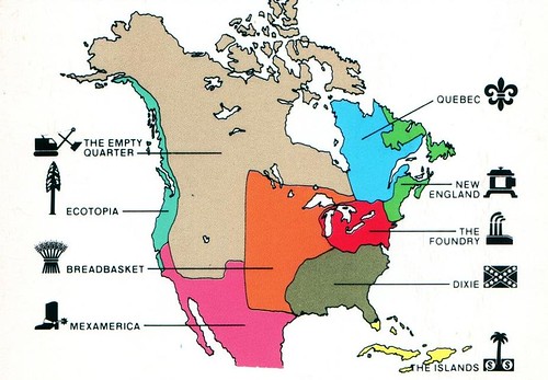
This made me recall my first encounter with the work of writer Joel Garreau, who in the 1990s popularized the phrase "edge city" to describe the booming but formless suburban commercial districts that were establishing themselves in nearly all US metro regions. But first, back in 1981, Garreau wrote The Nine Nations of North America. I read an excerpt in The Washington Post and was fascinated:
That was a long time ago, but he was on to something that people who think about ecology, land use, and social and economic issues are frequently forced to confront: the issues that we must address bear little relation to the political boundaries of states and municipalities (and, for that matter, countries). This poses immense challenges to the crafting of realistically implementable policy solutions.
And, besides, it's just plain interesting when applied to cultural characteristics such as food, music, and religion. While mobility, digital communications, fungible shoddy architecture and chain stores are doing their best to eradicate what is left of regional distinctions in America (e.g., almost no one who works in NRDC's Washington office is actually from the Washington metro area, and we all eat international ethnic food), there still remain some meaningful distinctions, not least those provided by nature, such as climate, vegetation, and landscape.
A post on the fascinating blog Strange Maps says that "Garreau's subdivision of the North American continent is the best-known example of what one might call bioregionalism or 'ecoregionalism'. This term, first emerging in the 1970s, puts great value on the 'politics of place'. Which means that the basis for policy and analysis are geographical areas, defined by their natural or cultural – but in any case 'organic' – boundaries (such as watersheds or prevalent type of industry)." It is interesting to compare Garreau's divisions with Warden's, which came 29 years later.
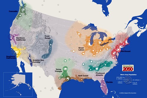
More relevant to the issues we usually discuss in this blog, perhaps, are the "megaregions" identified by the America 2050 project (see also my post on the subject from a while back) spearheaded by the Regional Plan Association. Their map, just above, is built not so much on commonality within vast geographic regions such as Garreau's "Breadbasket" or Warden's "Stayathomia" as on relationships among closely linked metropolitan areas such as the Dallas-Houston-San Antonio "Texas Triangle." But the map also shows "areas of influence" beyond the specific metro borders and begins to suggest larger regions, which you can see. The Great Lakes Region on America 2050's map, for example, lies entirely within Warden's Stayathomia and comprises Garreau's The Foundry as well as part of his Breadbasket.
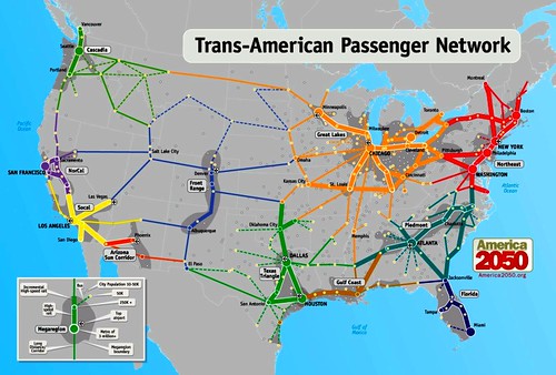
Interesting stuff. And it has practical application, too, such as the high-speed regional rail networks suggested by America 2050. They closely follow the megaregions:
America 2050 explains:
"As metropolitan regions continued to expand throughout the second half of the 20th century their boundaries began to blur, creating a new scale of geography now known as the megaregion. Interlocking economic systems, shared natural resources and ecosystems, and common transportation systems link these population centers together. As continued population growth and low density settlement patterns place increasing pressure on these systems, there is greater impetus to coordinate policy at this expanded scale."
Three different sources, all getting at the same thing: transcending political boundaries that bear little relationship to real-world problems, in order to better understand the actual boundaries that describe economic, cultural, and environmental commonality and distinction.
Kaid Benfield writes (almost) daily about community, development, and the environment. For more posts, see his blog's home page.
Link to original post


