Six Ways that Thoughtful Community Planning can Help Fight Climate Change
It is almost a tautology to declare that our future, and that of our children and their children, depends on how we shape our communities for the 21st century and beyond. Here in the US, we're going to be growing, and growing a lot: how we manage that growth will affect everything from how healthy our economy will be to how nourished and happy we will be as people to, yes, how healthy the future of our planet is. Frequently lost in the increasingly sharpening debate over climate change and global warming is that being thoughtful about managing future land development can make a significant difference in helping to curb carbon emissions and their very serious consequences.
Carbon and global warming
Although local temperatures fluctuate naturally, over the past 50 years the average global temperature has increased at the fastest rate in recorded history. And the trend is accelerating: the 10 hottest years on record have all occurred since 1990. Scientists believe that, unless we curb global warming emissions, average US temperatures could be from 3 to as many as 9 degrees higher by the end of the century. The results already include sea level rise, flooding, drought, wildfire, stronger storms as ocean currents heat up, and other serious threats to human life and welfare. Global warming is the most serious environmental crisis of our time.
These facts are not really in dispute. There is debate, mostly from politicians, over to what extent the crisis is man-made, and lots of debate over what to do about it. (The overwhelming scientific consensus is that warming is quite real, caused by man-made carbon dioxide pollution and other greenhouse gas emissions, and requires serious and immediate attention.) I say that, whatever one's inclinations on the details of these issues, surely we can all agree that we should reduce pollution, become more efficient in our use of carbon-emitting fossil fuels, and stop exacerbating the problem. Now.
Let's talk about how to do that, not whether.
The United States is a major emitter of global warming pollution, on both an absolute and a per capita basis. Yet until recently we have been embarrassingly slow in doing much about that. Earlier this week the federal Environmental Protection Agency took a very significant step forward in addressing the problem by proposing new limits on carbon pollution from electric power plants. Last year the Obama administration adopted new standards for fuel efficiency in cars and trucks, another major source of carbon pollution. The organization I work for, the Natural Resources Defense Council, has applauded these measures, and rightfully so.
Cutting carbon pollution with thoughtful community planning
But we mustn't stop there. According to Department of Energy estimates, about 39 percent of America's carbon emissions come from commercial and residential buildings; over 33 percent come from transportation, the majority of that amount from passenger and freight traffic – moving people and goods around and in between our communities. That's over 70 percent of our carbon emissions directly influenced by the built environment. We ignore the character and future of our built environment at our peril.
Transportation emissions are especially significant in our cities and suburbs. Research shows that we typically use more energy and thus emit more carbon getting to and from office buildings than we do heating, cooling, lighting and maintaining them. This is due in no small part to the fact that so many new office buildings have been built on completely car-dependent sites on the fringe of our metro areas. The pattern holds true for suburban residential buildings as well: data show that transportation energy so dwarfs building energy that even those suburban households with energy-efficient homes and cars use more energy and emit more carbon than ordinary households in urban, transit-served locations.
This is because, as development has spread out across the landscape, we have had to drive ever-longer distances to do stuff, from going to work to visiting the doctor's office to taking our kids to sports and school events. In the latter decades of the 20th century, poorly planned – or, in too many cases, simply unplanned – sprawling new land development caused us to grow about twice as fast in developed land as we did in population. Partly as a result, we grew traffic three times faster than we grew in population.
The good news is that growth in both sprawl and traffic has slowed considerably as people rediscover the benefits of living in cities and walkable suburban neighborhoods. We now have favorable market trends to build on as we figure out new approaches (and, in some cases, reclaim old ones) to create better, healthier communities that also happen to be less carbon-intensive.
With some seventy million new Americans expected by 2040, we have an exciting opportunity to bring lessons learned to bear, as we build an expected 50 million new and replacement homes and 78 billion square feet of new and replacement nonresidential building space. Half the built environment we will have on the ground in 2040 isn't there yet, according to real estate analysts. We can get it right, and here's how:
1. Build in the right places.
It is not commonly understood, but needs to be, how much the location of development affects the amount of driving we have to do, and thus the amount of greenhouse gas pollution (mostly carbon dioxide) we emit. In fact, the most exhaustive research I have seen on the relationship between land use and household travel behavior indicates that location – how close a home or development is to the people, goods and services its inhabitants need to reach throughout a metropolitan region – is by far the most significant indicator of average driving rates and consequent emissions from and to that home or development. As a general rule, the more central the location, the lower the rate of driving.
This is primarily because central locations tend to shorten average driving distances; central locations (including some suburban centers) also tend to have higher rates of walkability and more density, which facilitates transit use. Residents of central locations don't have to drive as far or as often, compared to those in sprawling outer locations.
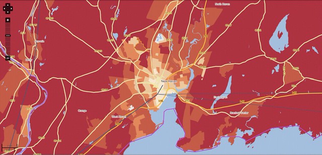
This is backed by extensive data. Above is a carbon map of metropolitan New Haven, Connecticut, courtesy of the Center for Neighborhood Technology's extraordinarily useful H+T (housing plus transportation) Affordability Index. (This rich database maps all US metro areas on a range of housing and transportation indicators; for today's article I chose maps that depict the spatial distribution of greenhouse gas emissions per household from automobile use.) The lighter the shading on the map, the lower the rate of carbon emissions per household from driving in the shaded area. Notice how the most central parts of the map – downtown New Haven and surrounding neighborhoods – generally have lighter colors, while the most outlying areas generally have the darkest.
Indeed, households in the lightest beige areas emit, on average, less than 3.3 metric tons per year of carbon dioxide from driving. Households in the darkest red areas, on average, emit more than 8.6 metric tons per year. That's a big difference.
Sadly, the regional average for households in the New Haven metro area for greenhouse gas emissions from driving is a fairly high 8.68 metric tons per year, or about what an average household on the border between the darkest red and darkest orange areas emits. That's a lot. But the good news is that the map shows us where to locate to do better than that and lower emissions.
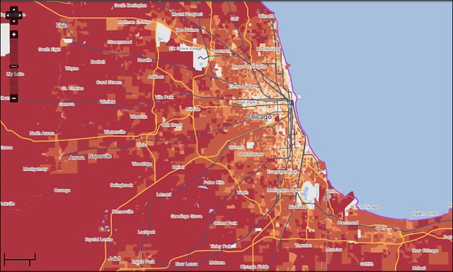
Chicago, mapped above, is a larger and more complex metropolis than New Haven, but note that the same pattern holds: the farther one gets from downtown, the higher the average household rate of carbon emissions from driving. (This pattern holds in metro areas throughout the country.) But notice also that there are plenty of areas outside of downtown with shading in between the lightest and darkest. These places, too, hold some promise for new development, since all but the darkest two shades have lower rates of greenhouse gas emissions from driving than the Chicago metro average of 7.66 metric tons per year per household.
Match the lightly shaded areas of the map with a map of development of New Haven or Chicago (or any other metro area, for that matter) and you'll generally find that the lowest rates of emissions occur in places that have concentrations of existing development. To reduce carbon emissions from future building, planners should help developers find obsolete industrial land (every major city has it), vacant parcels, and underutilized aging commercial corridors ripe for redevelopment. Think regional centers and suburban subcenters. One of the best parts of this strategy, by the way, is that existing single-family neighborhoods generally do not need to be disturbed. We can do this.
I spent a lot of verbiage on the location of development because of its paramount importance to reducing carbon emissions, and because the relationship between location and emissions is so poorly understood. The other five things planners should do to fight climate change are more intuitive and more easily explained. Let's get to them.
2. Get connected.
The second thing we should do is improve the connectivity among and within our neighborhoods and metro regions. We can do this in two ways. The first is through better street patterns.
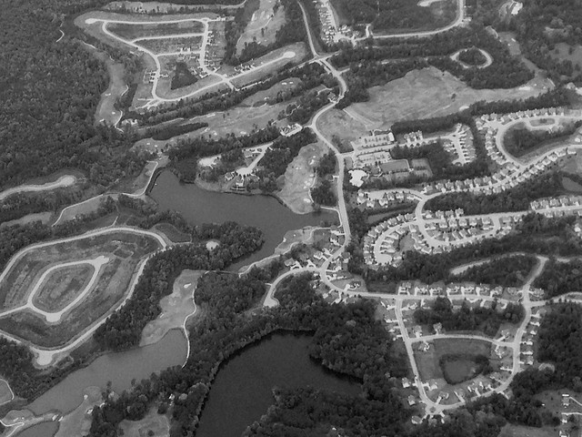
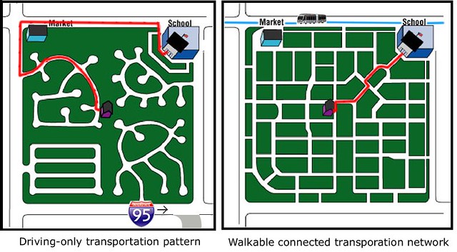
While location is the single most important factor in determining average rates of driving from a given development, the second most important, according to research, is the degree of street connectivity. Consider the diagram above, created by my friend Michael Ronkin. Notice how well-connected streets, generally characterized by more intersections and shorter blocks, shorten travel distances. This not only further reduces driving distances; it also makes neighborhoods more walkable, enabling some people to avoid car trips altogether for some purposes. The degree of street connectivity is the single most important indicator of how much walking takes place within a neighborhood.
This means that, to reduce carbon emissions further, thoughtful planning should help direct developers to sites on well-connected streets – and, in developments large enough to involve the building of new street infrastructure, make sure that the new streets are well connected to each other and to streets outside the immediate development.
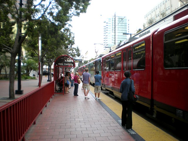
Another thing we should do to improve connections and reduce emissions is take advantage of and strengthen public transit. There is a plethora of research on the usefulness of good public transportation in reducing driving and strengthening the economy. One of my favorite studies undertook painstaking empirical research in 17 locations and found that, on average, the presence of strong public transit accessible to development reduces car trips by 49 percent in the morning peak period and 48 percent in the evening peak, compared to what would be expected from standard engineering estimates typically used by municipalities. Additional data from the transit-rich Washington, DC suburb of Arlington, Virginia shows how concentrating development around transit stations in mixed-use corridors not only preserves single-family neighborhoods but also boosts transit usage and walking way above national averages.
3. Plan for convenience.
Speaking of mixed-use development, another way to shorten driving trips and substitute walking for driving in more cases is to locate the places where we go to school, worship, shop, dine, take our dry cleaning, and so on closer to each other and to the places where we live. Research shows that the presence of nearby retail increases walking some 25 percent; data also show that residents of walkable, mixed-use neighborhoods weigh as much as ten pounds less, on average, than residents of sprawling, automobile-dependent neighborhoods, apparently because they walk more. This is so even when other factors such as age, income, and ethnicity are taken out of the equation.
In some places, planning for convenience can mean true mixed-use, as in having apartments in the same building or next door to commercial uses. Indeed, this is what a significant portion of the market prefers.
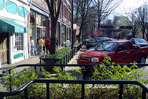
But there are other ways, too. I happen to live in a quiet, older residential neighborhood. It has safe streets and lots of kids. Sitting on my front porch, it feels more like a village than a city. But I can walk two blocks to a commercial corridor and find five restaurants, the dry cleaners, a UPS store, a convenience store, an optometrist, and even a toy store. If I walk two more blocks, up the commercial street, I can find lots more restaurants, a hardware store, several churches, and a Metro station that can take me to work. I sometimes go entire weeks without using my car (though I enjoy it when I do; I'm not anti-car).
I know I'm lucky. This is all because my part of our city (Washington) was built many decades ago. The overwhelming majority of people who live in newer suburbs don't have those choices. They should. Let's put more of our newer neighborhoods, too, within walking distance of everyday conveniences, with safe walking routes to get to and from them.
4. Build green.
As noted, residential and commercial buildings are responsible for around 39 percent of America's total carbon emissions. Indeed, US buildings alone are responsible for more carbon dioxide emissions annually than those of any other country except China. Most of these emissions come from the combustion of fossil fuels to provide electricity for heating, cooling and lighting, and to power appliances and other electrical equipment. Commercial and residential buildings are tremendous users of electricity, accounting for more than 70 percent of electricity use in the US.
Making our buildings more energy-efficient and climate-friendly can play a major role in reducing global warming. According to the US Green Building Council, if half of new commercial buildings were built to use 50 percent less energy, it would save over six million metric tons of carbon dioxide annually for the life of the buildings—the equivalent of taking more than a million cars off the road every year.
We know how to do this. In fact, in many ways traditional "original green" building practices – common "before the thermostat age," as architectural sage Steve Mouzon likes to say – can help, even without advanced technology. These include such measures as attention to solar orientation and shading, high ceilings, taking advantage of natural ventilation and daylighting, and insulation. Indeed, many of these practices are the foundations of today's green building rating systems.
With the added efficiency that can be achieved through the latest building technology, the Green Building Council also estimates that the average LEED-certified building uses 32 percent less electricity and saves 350 metric tons of CO2 emissions annually, compared to a conventional building. This needs to become standard practice.
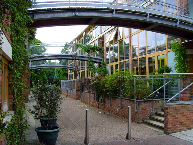
With ambition, one can do much better than even that considerable accomplishment, of course. London's BedZED, photographed above, is an affordable housing development that incorporates not just state-of-the-art resource efficiency but also on-site renewable resource generation. BedZED ("Beddington Zero Emission Development") is on track to become a zero-emission development that will emit no more carbon than it produces on-site through clean technology. Read about it here and let your imagination consider the possibilities for future community development in the US. (Matt and Kelly Grocoff's historic Victorian home in Ann Arbor, Michigan, is another fascinating net-zero retrofit.)
5. Incorporate living nature.
There are many, many compelling reasons for incorporating nature into development, as I have written before. I won't repeat the basics here, but I will add that nature also helps fight climate change. At the neighborhood scale, living greenery absorbs carbon dioxide from the atmosphere. It also has a cooling effect, reducing urban "heat islands" and thus reducing electricity needs for summertime air conditioning. Green roofs, street trees, pocket parks, and urban gardens are among the measures we can employ, in concert with the others discussed above, to help reduce greenhouse gas emissions.
6. Save the countryside.
The same benefits of maintaining living nature that apply at the neighborhood scale also apply at the regional scale and beyond. Worldwide, deforestation is the second leading contributor of carbon emissions after the burning of fossil fuels. Conserving our forests and farmland help absorb carbon from the atmosphere.
Moreover, saving wilderness and the rural landscape is the flip side of developing in the right places. We will never fully reduce our transportation emissions to a reasonable level if we don't put a stop to suburban sprawl.
Already moving in the right direction
Fortunately, we can accomplish these things largely by better aligning planning and development practices with emerging but now-clear market forces. In particular, the latest data show that, since the mid-1990s, the annual increase in developed land in the US has been going down, not up. Central counties are now growing faster than outlying counties. Investment is also flowing faster into urban cores than to sprawling suburbs.
We're driving less, too: vehicle miles traveled per household peaked in the US in 2005 and have been going down ever since, even since the end of the Great Recession. Aggregate miles driven per year in the US have also begun to shift downward.
Moreover, the lifestyle preferences of the Millennial generation, now coming of age, are markedly different and more urban than those of their predecessors. According to analysis by real estate industry advisers RCLCO, 31 percent of Millennials prefer a "core city." What is particularly significant about this finding is that it is twice the portion of the preceding generation when polled at the same age. Perhaps more to the point, two-thirds wish to live in walkable places and town centers, whether in the inner city or in suburbs. A third will pay more for walkability, and half will trade space for it.
University of Utah professor Arthur C. Nelson, an eminent housing demographer, believes that, contrary to what occurred in previous generations, there will be no growth in the demand for large-lot housing: half of all new housing demand between now and 2040 will be for attached homes, the other half for small-lot homes. Although there will be a continuing demand for large-lot housing, that isn't where the growth is; demand for large lots will constitute only 25 percent of the total market by 2040. Similarly, the number of adults of child-rearing age and the number of households actually living with children will comprise a much smaller portion of the overall housing market than in previous decades. Nelson estimates that 87 percent of the growth in the housing market through 2040 will comprise households without children.
In other words, there's a reason why city living is becoming more expensive and suburbs less so: demand for what cities offer is up, and demand for automobile-dependent suburbs, relatively speaking, is down.
As for Millennials and driving, miles driven by Americans aged 16 through 34 dropped an amazing 40 percent per capita over the last decade, compared to the same age group in the previous decade. In the same decade, bicycling trips per person in the age group went up 24 percent while walking went up 16 percent. Twenty-six percent of Americans aged 16-34 do not even have a driver's license.
In California, smarter land use and transportation planning to reduce carbon pollution is now the law of the land. That state's SB375, the Sustainable Communities and Climate Protection Act of 2008, requires that each metropolitan area in California design and implement a plan to reduce greenhouse gas emissions from transportation in compliance with targets set by the state's Air Resources Board. For example, the metropolitan planning organization for Southern California (the state's largest and most populous metro area, including Los Angeles) finalized a plan in 2012 that, through measures such as those outlined above, would reduce per capita transportation emissions of 9 percent by 2020 and 16 percent by 2035.
In addition to meeting the targets, the plan would invest $246 billion in public transportation over a 25-year period; triple funding for programs to support walking and bicycling; place 60 percent more housing in transit-accessible locations; create 4.2 million jobs in the region, and place 87 percent of all jobs within a half mile of transit service; reduce pollution-caused respiratory problems by 24 percent, resulting in $1.5 billion per year in health care savings; and save over 400 square miles of farmland and other open space from development. That is serious ambition, but also evidence of how better planning can achieve ambitious goals, including the all-important goal of fighting climate change.
The era of unfettered sprawl is over, and just in time, given the urgency of the need to reduce climate change emissions. The question before us now is how to live a sustainable and prosperous lifestyle suited to 21st-century realities. I believe we can improve people's lives and improve prospects for the planet simultaneously.
I could go on
Entire books could be written on this subject, and have been. (See, for example, Urbanism in the Age of Climate Change, by innovative California architect and planner Peter Calthorpe, and Growing Cooler, published by the Urban Land Institute and written by a team of researchers led by University of Utah professor Reid Ewing.) But I've already written my quota of books for the year, thank you very much. I'm not going there.
Instead, I'm offering these six simple steps. They are by no means exhaustive, and neither are they revolutionary, by intention. They are intended to be pragmatic, sensible, in keeping with American lifestyle preferences, and implementable. They are not about beating ourselves up for past mistakes but, instead, about how we accommodate future building in a forward-looking way that meets market preferences while improving conditions for people and the planet.
There's plenty of room for tinkering with the details, by the way. The important thing is to adopt the principles and get to the work ahead.
Move your cursor over the images for credit information.

