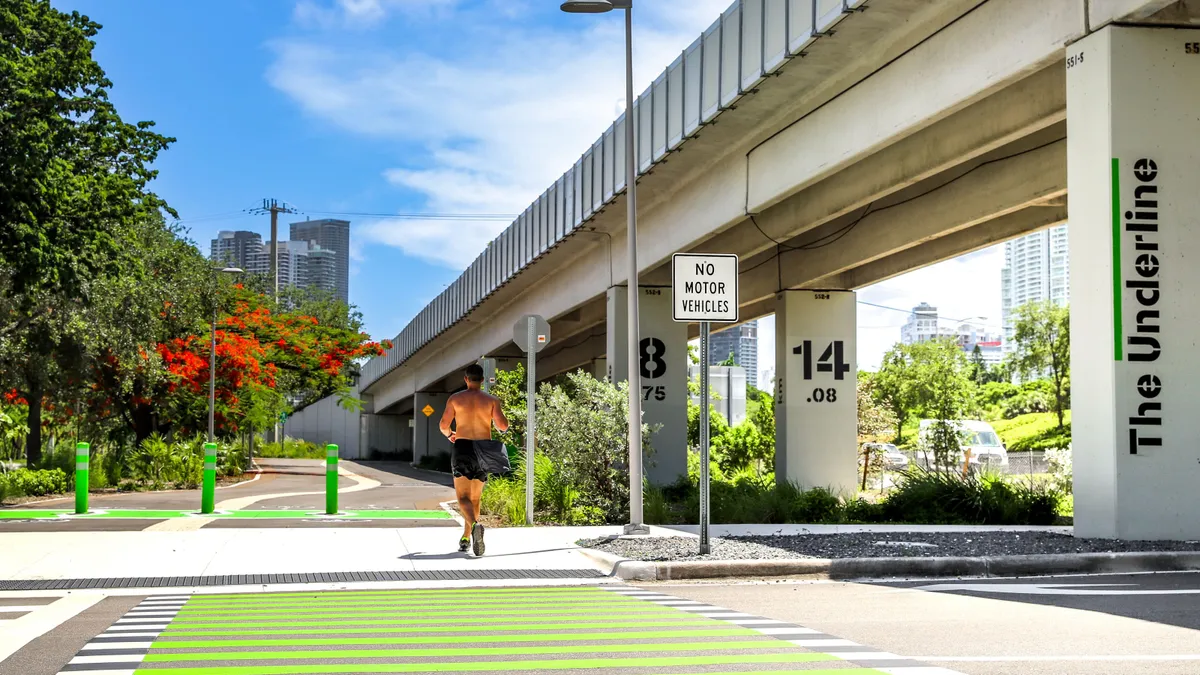
In Miami, years of work to build a 10-mile urban trail and linear park below elevated public transit train tracks are nearing fruition.
The Underline is slated to be complete in 2026, but it’s already opened some of its paths and recreational areas to pedestrians, cyclists and other visitors. The first half-mile opened in 2021, and another more than 2 miles opened in spring 2024, bringing hydration and bike repair stations, free WiFi, public art, bioswales, outdoor gym space and a 50-foot communal “dining room” table to the stretch of land.
Patrice Gillespie Smith is among the leaders of this effort as the president and COO of the nonprofit Friends of The Underline, which is partnering with local governments on developing the public space. In this conversation with Smart Cities Dive, Gillespie Smith explains what makes The Underline special and the challenges the project faces as it undergoes its final construction period.
Editor’s note: This interview has been edited for clarity and brevity.
SMART CITIES DIVE: What is unique about The Underline compared with other projects you’ve worked on that focus on enhancing walkability and urban greening?
PATRICE GILLESPIE SMITH: With Complete Streets efforts, you make sure every mode is represented in that street right-of-way. What I really admire about The Underline and what Meg [Daly], our founder, did is instead of trying to put it all on a road in quite an auto-centric community, she identified an underutilized space and said this is where our multimodal trail can go but also [be] a linear park. That's how we're different in South Florida: We're not just a trail. We are viewed as a transportation corridor.
Because we have about a 100-foot-wide right-of-way, we have this opportunity to be a resilience intervention. By the time we're finished in 2026, we'll have more than 500,000 plants and trees that are native to South Florida. Miami is rapidly developing so much so that we're losing a lot of our green space. The average in the country is to have 15% set aside for open spaces for your city, and we only have 7% set aside.
We also offer 200 free programs every year, whether it's free yoga, Zumba, planting in our gardens for volunteers or even learning basketball skills from the Miami Heat or soccer skills from the U.S. Soccer Federation.
What opportunities and challenges come with combining a park with a transportation corridor?
When we started doing our planning more than 10 years ago, we asked the community what their priorities were. Consistently, even when we just had a round of public meetings earlier this year, the community says safety is their number one priority, then nature and then interacting in that community gathering space. So that's really how we've planned the space.
It is first and foremost a transportation corridor. In most cases on the multimodal trail, the biking element is separated from the pedestrian element. That’s something that cyclists were really clear about; they said “I don't want to have to worry about hitting a pedestrian if I'm going 20 mph.” We really did try to separate that, but I'm going to be honest with you, in [the Brickell neighborhood], where there are hundreds of thousands of people coming through on a monthly basis, you're not going to be able to move that quickly. But almost every place else, you're going to have a nice dedicated right-of-way where you can bike and not have to worry about conflicts.
Then we created these amenity areas where you can come and gather. In phase one, we have a 50-foot dining room table where anybody can sit down. We also have public art throughout that people can experience without standing in the trail. Our users have really learned to coexist, but there’s definitely some forethought in design.
What are the challenges that your team is still trying to figure out how to solve?
I think every city struggles with engineers who are educated in traditional modes of transportation and who are very risk-averse. It took us two years for our founder to get permission to create these very prominent green crosswalks [to separate the bike lane from the pedestrian path at street crossings]. The idea is to tell cyclists to go on the green side, but it also is to tell the motorist that there's going to be a lot more pedestrian and bicycle traffic in this area.
The other thing we're really focused on is leading pedestrian intervals [at traffic signals] to make sure that pedestrians get that seven- to 10-second lead before a motorist is allowed to take a left turn.
As far as green infrastructure goes, we are on a contaminated site that was originally the site of a railroad 100 years ago. Then it became the site of the Miami Metrorail, which is above us. Because of that, the soil that we are on top of is contaminated with arsenic. It was our job to clean that soil. That is incredibly expensive.
What green infrastructure benefits does The Underline provide for Miami?
Ultimately, we feel it's going to be 10 miles of bioswales. That's really critical because we have a lot of extreme storm events that can just wash out entire areas but that can also cause problems with saltwater intruding into the aquifer. The bioswales are going to make sure that the water slows down, is cleaned and is able to return to the aquifer purified. The aquifer is our drinking source, so it's very important.
We're not only planting lots of new trees, but we're pioneering something called a microforest. It's a Japanese afforestation method called Miyawaki, and it's the first time that it's being used in South Florida. It’s still relatively new in the U.S. The whole idea is that in these small parcels, sometimes the size of a basketball court, we're going to plant 1,000 seedlings, and they're going to grow 10 times faster than the average urban forest. They're going to have 10 times the biodiversity because we're controlling it.


